


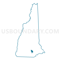
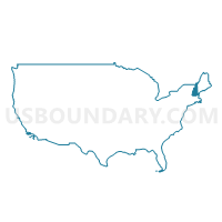
Manchester City PUMA, New Hampshire
About
Outline

Summary
| Unique Area Identifier | 193365 |
| Name | Manchester City PUMA |
| State | New Hampshire |
| Area (square miles) | 34.96 |
| Land Area (square miles) | 33.10 |
| Water Area (square miles) | 1.86 |
| % of Land Area | 94.67 |
| % of Water Area | 5.33 |
| Latitude of the Internal Point | 42.98468910 |
| Longtitude of the Internal Point | -71.44389320 |
Maps
Graphs
Select a template below for downloading or customizing gragh for Manchester City PUMA, New Hampshire


Neighbors
Neighoring Public Use Microdata Area (by Name) Neighboring Public Use Microdata Area on the Map
- Hillsborough County (Southeastern)--Greater Nashua City PUMA, NH
- Hillsborough County (Western) PUMA, NH
- Outer Manchester City PUMA, NH
Top 10 Neighboring County (by Population) Neighboring County on the Map
Top 10 Neighboring County Subdivision (by Population) Neighboring County Subdivision on the Map
- Manchester city, Hillsborough County, NH (109,565)
- Merrimack town, Hillsborough County, NH (25,494)
- Londonderry town, Rockingham County, NH (24,129)
- Bedford town, Hillsborough County, NH (21,203)
- Goffstown town, Hillsborough County, NH (17,651)
- Hooksett town, Merrimack County, NH (13,451)
- Litchfield town, Hillsborough County, NH (8,271)
- Auburn town, Rockingham County, NH (4,953)
Top 10 Neighboring Place (by Population) Neighboring Place on the Map
Top 10 Neighboring Elementary School District (by Population) Neighboring Elementary School District on the Map
- Bedford School District, NH (21,203)
- Hooksett School District, NH (13,451)
- Auburn School District, NH (4,953)
Top 10 Neighboring Unified School District (by Population) Neighboring Unified School District on the Map
- Manchester School District, NH (109,565)
- Merrimack School District, NH (25,494)
- Londonderry School District, NH (24,129)
- Goffstown School District, NH (17,651)
- Litchfield School District, NH (8,271)
Top 10 Neighboring State Legislative District Lower Chamber (by Population) Neighboring State Legislative District Lower Chamber on the Map
- State House District 27, Hillsborough County, NH (45,635)
- State House District 3, Rockingham County, NH (29,082)
- State House District 17, Hillsborough County, NH (27,005)
- State House District 7, Hillsborough County, NH (26,436)
- State House District 19, Hillsborough County, NH (25,494)
- State House District 18, Hillsborough County, NH (21,203)
- State House District 9, Merrimack County, NH (13,451)
- State House District 13, Hillsborough County, NH (10,188)
- State House District 10, Hillsborough County, NH (9,346)
- State House District 9, Hillsborough County, NH (9,219)
Top 10 Neighboring State Legislative District Upper Chamber (by Population) Neighboring State Legislative District Upper Chamber on the Map
- State Senate District 9, NH (57,859)
- State Senate District 16, NH (55,772)
- State Senate District 18, NH (54,574)
- State Senate District 14, NH (53,549)
- State Senate District 20, NH (52,778)
Top 10 Neighboring 111th Congressional District (by Population) Neighboring 111th Congressional District on the Map
Top 10 Neighboring Census Tract (by Population) Neighboring Census Tract on the Map
- Census Tract 131, Hillsborough County, NH (8,271)
- Census Tract 28, Hillsborough County, NH (7,815)
- Census Tract 24, Hillsborough County, NH (7,118)
- Census Tract 29.01, Hillsborough County, NH (7,086)
- Census Tract 29.02, Hillsborough County, NH (6,257)
- Census Tract 27.02, Hillsborough County, NH (6,029)
- Census Tract 10, Hillsborough County, NH (6,027)
- Census Tract 26, Hillsborough County, NH (5,746)
- Census Tract 18, Hillsborough County, NH (5,730)
- Census Tract 442, Merrimack County, NH (5,646)
Top 10 Neighboring 5-Digit ZIP Code Tabulation Area (by Population) Neighboring 5-Digit ZIP Code Tabulation Area on the Map
- 03103, NH (36,476)
- 03104, NH (32,798)
- 03102, NH (31,096)
- 03054, NH (25,477)
- 03053, NH (23,957)
- 03110, NH (21,203)
- 03045, NH (13,560)
- 03106, NH (13,374)
- 03109, NH (10,314)
- 03052, NH (8,258)